Posts
The melting roads of Yellowstone National Park - Caldera Chronicles
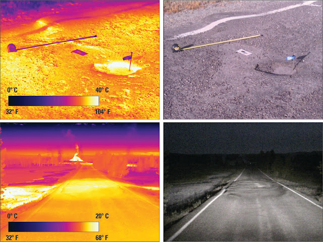
The melting roads of Yellowstone National Park Perhaps you’ve heard the legend of the melting roads in Yellowstone National Park. The rumor is based in truth but, as you might expect, badly misrepresented. It has nothing to do with potential volcanic activity; rather, thermal ground and asphalt don’t play well together and pose a considerable challenge for road maintenance and engineering. Yellowstone Caldera Chronicles is a weekly column written by scientists and collaborators of the Yellowstone Volcano Observatory. This week's contribution is from Michael Poland, geophysicist with the U.S. Geological Survey and Scientist-in-Charge of the Yellowstone Volcano Observatory. No doubt you’ve heard the story—roads have melted in Yellowstone National Park, which is supposedly evidence that the region is “heating up” and that a volcanic eruption is imminent. This story gained a lot of traction in 2014—that was the year of a magnitude-4.8 earthquake (the largest to have occurred in Y
Caldera chronicles: Why drilling the Yellowstone volcano to stop eruptions or generate power is a bad idea - USGS
Caldera chronicles: Why drilling the Yellowstone volcano to stop eruptions or generate power is a bad idea
Arsenic in Yellowstone’s thermal waters - USGS

Arsenic in Yellowstone’s thermal waters Release Date: December 6, 2021 Yellowstone’s thermal waters are more than just hot—they also contain a variety of elements, some of which are potentially toxic! Arsenic is an example, but the concentrations of this element depend on the style of the thermal feature. Perhaps paradoxically, acidic thermal features contain much less arsenic than neutral ones! Yellowstone Caldera Chronicles is a weekly column written by scientists and collaborators of the Yellowstone Volcano Observatory. This week's contribution is from Blaine McCleskey, research chemist with the U.S. Geological Survey. Photograph of the Old Faithful Geyser erupting in Yellowstone National Park. Waters from Old Faithful contain arsenic concentrations of about 1,500 µg/L. Arsenic is a geogenic, or naturally occurring, chemical element in surface- and groundwaters that is of great public-health concern. Thermal
The largest landslide in the world - Caldera Chronicles

The largest landslide in the world Release Date: November 22, 2021 Yellowstone is well-known as one of the largest volcanic systems in the world. Few people know, however, that the largest-known subaerial landslide on Earth is located just next door. Map of the Heart Mountain slide block. From Mitchell et al., 2015 (" Catastrophic emplacement of giant landslides aided by thermal decomposition: Heart Mountain, Wyoming ." Earth and Planetary Science Letters 411: 199-207), modified from Anders et al. (2010). Yellowstone Caldera Chronicles is a weekly column written by scientists and collaborators of the Yellowstone Volcano Observatory. This week's contribution is from Annie Carlson, Research Coordinator at the Yellowstone Center for Resources, Yellowstone National Park. Among the geologic hazards in the Yellowstone region, you may be familiar with the possibility of earthquakes, hydrothermal explosions, and vo
The Changing Moods of Colloidal Pool in Norris Geyser Basin - Caldera Chronicles
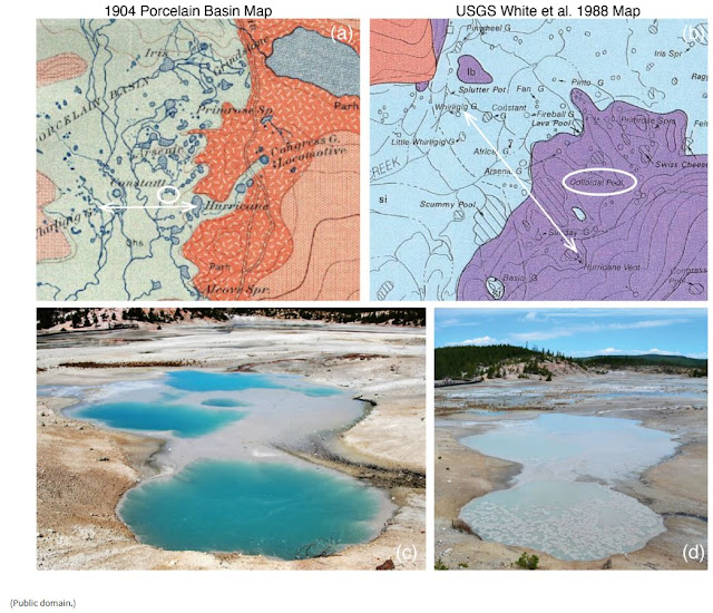
The Changing Moods of Colloidal Pool in Norris Geyser Basin By Lauren Harrison, PhD , USGS Release Date: November 15, 2021 Many of Yellowstone’s hot springs, geysers, mud pots, and fumaroles look different depending on the season, year, or sometimes even the day one visits. Colloidal Pool, in Norris Geyser Basin, is an interesting example of a feature that changed over the course of summer 2021. Yellowstone Caldera Chronicles is a weekly column written by scientists and collaborators of the Yellowstone Volcano Observatory. This week's contribution is from Lauren Harrison, postdoctoral researcher with the U.S. Geological Survey. Comparison of (a) 1904 Historical map with (b) 1988 USGS map . Colloidal Pool is a large, labeled pool roughly located on a straight line between Hurricane vent and Whirligig Geyser on the 1988 map (b); this same transect on the 1904 map (a) shows no feature at that location (white circle). Note: maps are not at th
Scientists can now “sniff” Yellowstone gases in real time - Caldera Chronicles

Scientists can now “sniff” Yellowstone gases in real time Release Date: September 13, 2021 Much is known about how the chemical compositions of gases vary across the Yellowstone volcanic system, but how they vary in time has remained largely a mystery. Our understanding should greatly improve with a recent installation of a station that continuously monitors gases and communicates those data in real time. Yellowstone Caldera Chronicles is a weekly column written by scientists and collaborators of the Yellowstone Volcano Observatory. This week's contribution is from Jennifer Lewicki, research geologist with the U.S. Geological Survey in Menlo Park, CA. USGS scientist Laura Clor performing maintenance on the SNIF multi-GAS station on Mount St. Helens, Washington. (Credit: Peter Kelly, USGS. Public domain.) Over the past several decades, scientists have sampled gases from all of the major thermal areas of Yellowstone i
Locating earthquakes in the Yellowstone region - Caldera Chronicles

Locating earthquakes in the Yellowstone region Release Date: August 30, 2021 Ever wonder how seismologists determine the location of an earthquake in Yellowstone? It’s an intricate process, but thanks to experienced scientists, up to thousands of earthquakes are located in the Yellowstone region every year! Yellowstone Caldera Chronicles is a weekly column written by scientists and collaborators of the Yellowstone Volcano Observatory. This week's contribution is from Jamie Farrell, assistant research professor with the University of Utah Seismograph Stations and Chief Seismologist of the Yellowstone Volcano Observatory. Record section showing horizontal component seismograms from stations in the Yellowstone region from the M4.8 earthquake that occurred near Norris Geyser Basin on March 30, 2014. The vertical blue dashed line represents the origin time of the earthquake at 12:34:39.16 UTC. The red line represents th
“Land of the burning ground”: Yellowstone’s Native American history and traditions - USGS

“Land of the burning ground”: Yellowstone’s Native American history and traditions Release Date: July 26, 2021 We sometimes think of Yellowstone as an untouched landscape, but humans have been present in the area for over ten thousand years! The history and traditions of Native Americans in Yellowstone are as rich as the landscape itself. Yellowstone Caldera Chronicles is a weekly column written by scientists and collaborators of the Yellowstone Volcano Observatory. This week's contribution is from Cole Messa, Ph.D. student and Professor Ken Sims, both in the Department of Geology and Geophysics at the University of Wyoming. To the Crow, it was the “land of the burning ground” or “land of vapors”; to the Blackfeet it was known as “many smoke”; to the Flatheads it was “smoke from the ground”; to the Kiowa it was called “the place of hot water.” Almost 150 years after its establishment by President Ulysses S. Grant, Yell
The travertine of Mammoth Hot Springs - Caldera Chronicles

An outlier of Yellowstone's thermal areas: the travertine of Mammoth Hot Springs Release Date: July 12, 2021 Early explorers during the separate Washburn, Hayden, and Hague expeditions of the 1870s were astonished by the massive terraces and pools of hot-spring limestone, better known as travertine, at Mammoth Hot Springs—a chemical oddity that is quite different from other Yellowstone thermal areas. Yellowstone Caldera Chronicles is a weekly column written by scientists and collaborators of the Yellowstone Volcano Observatory. This week's contribution is from Pat Shanks, research geologist emeritus with the U.S. Geological Survey. Map of Yellowstone National Park showing locations of thermal basins that host hot springs, geysers, and mudpots. Dark green areas host alkaline-chloride fluids. Yellowstone Caldera margin shown as bold dashed line. (Public domain.) Three main varieties of hot spring fluids are r
The day that Porkchop Geyser exploded - USGS

The day that Porkchop Geyser exploded Release Date: June 28, 2021 Small hydrothermal explosions—steam blasts—are common at Yellowstone, occurring every year or two. Most happen in the backcountry and are not observed by people. In 1989, however, Porkchop Geyser blew up right in front of several observers on an otherwise sunny September afternoon. Yellowstone Caldera Chronicles is a weekly column written by scientists and collaborators of the Yellowstone Volcano Observatory. This week's contribution is from Michael Poland, geophysicist with the U.S. Geological Survey and Scientist-in-Charge of the Yellowstone Volcano Observatory. Porkchop Geyser erupting in August 1989. (Credit: Jim Peaco, National Park Service. Public domain.) Norris Geyser Basin is one of the most unique parts of Yellowstone National Park. The basin hosts both acidic and neutral hot springs —a somewhat unusual combination—is the location of some